The Kennebec River is magical, rising from Moosehead Lake and cascading to the Atlantic Ocean. And where there’s a river there’s usually a valley…and this one’s spectacular. We’ll ride through the southern portion of the Kennebec Valley, as we’ll connect to Midcoast Maine.
There are few places on the East Coast where you can hike a mountain and, with a turn of your head, shift your eyes from terra firma to a sparkling sea and enchanted islands below. Maine’s Midcoast is one such place. Tucked within the Maine coastline are picturesque villages that bloom to vibrant waterfronts where Maine’s foodie scene continues to flourish. We’ll spend a good portion of the week exploring those seaside villages.
2019 Route Information

WATERVILLE
The City of Waterville is located on the banks of the Kennebec River in Maine. Waterville takes great pride in its downtown, with seven structures listed on the National Register of Historic Places. Within the City limits you will find a unique mix of shops and restaurants, Thomas College and Colby College.
Outdoor enthusiasts will delight over the miles of hiking trails located throughout the City, including those found at the four-season Quarry Road Recreation Area. Quarry Road also provides cross-country skiing, snowshoeing and snow tubing in the winter months and biking, kayaking and walking opportunities in the spring, summer, and fall. The Kennebec River also offers spectacular fishing and boating opportunities.
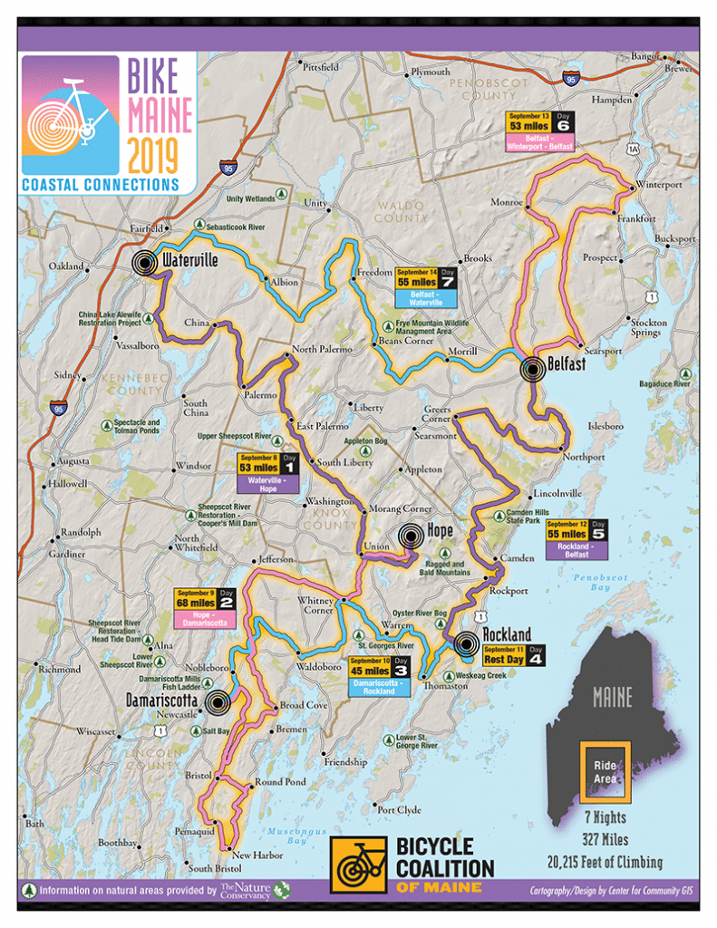
Waterville to Hope Route Description
The BikeMaine 2019 route begins in Waterville, crossing the Kennebec River via the historic Two Cent Bridge into Winslow, before swinging southeast into the rolling hills of rural Kennebec and Waldo counties. We will skirt the north shore of China Lake—a favorite of anglers across the state—then crisscross past several smaller ponds as we ride through the town of Palermo. Straightening out, the route continues through South Liberty and its surrounding farmland before crossing into Knox County and the town of Union, a cradle of early industry in the state and now home to the Matthews Museum of Maine Heritage and the annual Union Fair. We finish the day’s ride just around the corner in Hope, at Alford Lake Camp.
Mileage: 54.9 miles
Elevation: 4,127 feet
Click here for GPX file and Ride With GPS map
Click here to download a PDF map and cue sheet
ALFORD LAKE CAMP
Celebrating its 113th summer, Alford Lake Camp is one of the oldest residential girls camps in the world. ALC is located on the side of a hill on the east side of Alford Lake in Hope, Maine. The camps features over 300 acres of wide-open fields, lakeside woods, and trails. Campers enjoy traditional tent living, with 37 wood frame tents nestled in the woods. Crystal clear and very quiet, Alford Lake is one mile across and eight miles around.
Alford Lake Camp (Hope) to Damariscotta Route Description
This day will be one to remember. Leaving our camp behind, we will head west to Jefferson, before turning south to pedal along the eastern edges of Damariscotta Lake and Pemaquid Pond, and onto the historic Pemaquid Peninsula, home of some of the earliest and most embattled frontier settlements in New England. Awash in history and scenic beauty, we will pedal south through Broad Cove and out to Round Pond, a quaint village with a nicely protected and bustling harbor. We will turn back north at New Harbor and ride into Damariscotta, our home for the evening, at the Coastal River Association’s historic Round Top Farm.
Mileage: 68.4, with optional 6.4-mile extension to Pemaquid Pt. Lighthouse
Elevation: 3,734 feet
Click here for GPX file and Ride With GPS map
Click here for route extension GPX file
Click here to download a PDF map and cue sheet
DAMARISCOTTA
The Damariscotta Region has rich history in shipbuilding, oysters and maritime traditions. Today, the vibrant downtown area of the Twin Villages of Damariscotta and Newcastle is bustling with shops, galleries and restaurants. A public boat launch in the municipal parking lot helps power this working waterfront with a renewed focus on oyster farming which has been a staple product from the Damariscotta River for millennia.
The River is well‐known for boating, fishing, and a thriving aquaculture industry that produces both oysters and the sweet local mussels popular in area restaurants. Damariscotta is also the gateway to the Pemaquid and Damariscotta Lakes Region; the Pemaquid Point Lighthouse featured on the Maine State Quarter, the colonial restoration at Fort William Henry, and provides access to the Atlantic Coast and Monhegan Island.
Damariscotta to Rockland Route Description
Day three is a slight reprieve from the previous day’s ride, but showcases some of the most authentic communities in the Midcoast. The route winds north through Nobleboro before turning southeast and running parallel to a train line through Waldoboro, home of the famous Moody’s Diner. From there, riders zigzag their way to the coast through the farmlands of Whitney Corner to Warren—where you can still see remnants of 18th century canal locks—and finally a turn through Thomaston to Rockland’s Snow Marine Park. Riders will have the opportunity to rest and recuperate as we spend our layover day in Rockland.
Mileage: 52.5 miles
Elevation: 2,947 feet
Click here for GPX file and Ride With GPS map
Click here to download a PDF map and cue sheet
36.4-mile loop from Snow Marine Park to the Camden Snow Bowl (layover day ride)
Click here for GPX file and Ride With GPS map
ROCKLAND
Located on the beautiful clear waters of Penobscot Bay-Rockland’s heart is its harbor, which supports a diverse mix of uses. Abenaki people called it Catawamteak, or “great landing place”. It was settled in 1769, and the area was incorporated as the City of Rockland in 1854. In its early years, the City grew rapidly with shipbuilding and lime production. Over time, commercial fishing and tourism became and remain so to this day. In recent years, the City’s creative economy has taken off. Anchored by the Farnsworth Art Museum and the Maine Center for Contemporary Art, Rockland is now known as the Arts Capital of Maine. Today’s Rockland is a vibrant mix of commercial, cultural and recreational activity and is increasingly popular as a place to live, work and play.
Rockland to Belfast Route Description
After a restful day, Thursday’s route begins with a trio of “Rocks.” An invigorating five-mile climb out of Rockland finally gives way to a descent into Rockville, then continues east through Beech Hill Preserve to Rockport. A short hike will allow riders to enjoy views from the top of Beech Hill, which is home to a sod-roofed cottage built in 1913. Passing through downtown Rockport, home to the historic Rockport Opera House, the route stays coastal for a stretch before swinging northeast in Camden, staying on scenic roads along the shores of magical Megunticook Lake. From there it is the now-familiar zigzag pattern, this time northeast towards Lincolnville, then northwest through Belmont, home of some climbs that are sure to be memorable. A long, rolling descent brings us to Belfast, our seaside home for two nights.
Mileage: 51.7 miles
Elevation: 3,362 feet
Click here for GPX file and Ride With GPS map
Click here to download a PDF map and cue sheet
BELFAST
In the spring of 1770, Scots-Irish families from Londonderry, New Hampshire settled Belfast. Legend has it that the name Belfast, after the Northern Ireland city, was chosen by a coin-toss. Fear of British attack led these original proprietors to abandon the settlement during the American Revolution, but they returned in the 1780s to build a vibrant, prosperous outpost that would become the market center for the outlying area.
Abundant timber, a gently sloping waterfront and proximity to varied agriculture gave rise to shipbuilding and maritime commerce, with fortunes made in both. Prosperous shipbuilders and merchants constructed the architecturally significant houses that dominate our residential neighborhoods today. Two disastrous fires consumed much of the downtown area in 1865 and 1873, but merchants rebuilt with brick, creating a pleasing and long-lasting commercial district. The Belfast Historic Districts, residential and commercial, are included on the National Register of Historic Places. Today, Belfast is that rare combination of quiet small town with an active social and cultural life that is attractive to residents and visitors alike.
Belfast to Monroe to Belfast Route Description
Our loop ride out of Belfast heads north around Swan Lake to Monroe, and back. Though Tchaikovsky will not be in attendance, our pedalers will want to leap for joy at the miles of farmland and forest beauty that await. A brisk 10-mile climb kicks off the day’s route, with a brief respite through the town of Waldo, historic source of much of Belfast’s shipbuilding timber. From there it’s rolling hills through Brooks and Monroe, rural outposts of Waldo County. The route then swings south, past Swan Lake State Park—a meditative ride through some highlands with views of the lake below. We’ll follow the lake south through preserves and farmland back to Belfast and a well-established BikeMaine village.
Mileage: 42.8 miles
Elevation: 2,583 feet
Click here for GPX file and Ride With GPS map
Click here to download a PDF map and cue sheet
Belfast to Waterville Route Description
We bid Belfast goodbye on Saturday and point our wheels west. This route takes us through some of the agricultural heartland of the Midcoast. A big morning climb through Montville and Freedom will show us loads of organic farming in action, as well as the famous Lost Kitchen, if you can find it! With the slopes of Frye Mountain behind us, a rolling descent leads back in to Kennebec County. We pass through Albion, where Johnny’s Selected Seeds got their start and still operates to this day. Waterville and the end of the week’s ride awaits, though you may be tempted to make a stop at Big G’s Deli in Winslow before rolling back to the Head of Falls.
Mileage: 54.3 miles
Elevation: 3,253 feet
Click here for GPX file and Ride With GPS map
Click here to download a PDF map and cue sheet
January18
Belfast Repair Cafe
Coalition News
Pedestrian dies after being hit by car in Portland Old Port
(Portland, ME) January 8, 2025 – Joe Lewis, a 61-year-old attorney and beloved member of the Portland community, tragically passed…
Pedestrian dies after being hit by tractor-trailer on I-95 off-ramp in Fairfield
(Fairfield, ME) January 3, 2025 – A pedestrian in Fairfield is dead after he was struck by a tractortrailer truck…
The Bicycle Coalition of Maine to hire Andrew Zarro as next Executive Director
(Portland, ME) December 9, 2024 – On January 2, 2025, the Bicycle Coalition of Maine will welcome Andrew Zarro as…
BikeMaine 2019 Thanks Our Additional Sponsors:


